Multi-beam horizontal scanning capturing detailed forest floor, terrain elevations and trunk diameters.
Twin forward-facing stereoscopic cameras feeding reactive below-canopy autonomous pathing.
Lightweight aerospace carbon frame with vertical landing legs optimized for rugged terrain.
Malaysia’s regional partner for Deep Forestry—survey, analyze, and optimize stands with autonomous below-canopy flight, cloud AI, and hyperspectral diagnostics for forestry and mineral exploration.
Regional operations still rely on plot averages, manual calipers, and above-canopy flights that miss stem-level detail below the canopy. ALJ Global helps enterprises move to georeferenced, tree-by-tree inventory—with validated accuracy and ESG-ready insights.
Delivered in Malaysia and the region through ALJ Global, powered by Deep Forestry technology.
The three integrated systems below deliver this end-to-end.
01. CAPTURE
Drones navigate below the canopy, scanning every tree and uploading data to the cloud—fully automatic, no professional pilot required.
02. PROCESS
Cloud AI derives height, diameter, volume, species, and health per tree from fused 3D and spectral data—ground-truthed against field validation.
03. INSIGHT
Clear dashboards for harvest planning, carbon and ESG evidence, and biodiversity reporting—without requiring in-house GIS expertise.
Helping regional enterprises transition from estimated sampling plot averages to georeferenced tree-level assets for better margin planning and EUDR reporting.
Flies autonomously between tree rows, no professional pilot required. Builds a high-resolution 3D replica of every stem with analysis along the full trunk, surveying 500+ trees in a 10-minute flight (up to 1 ha per sortie). Data uploads to the cloud automatically for processing.
Flown above the canopy to scale capture across the landscape. Hyperspectral-LiDAR fusion delivers a 3D replica with species and health signals per tree, 50,000+ trees in 30 minutes, up to 100 ha per flight, extending below-canopy ground truth to stand scale.
Automated point cloud segmentation and cloud AI analysis when you connect the drone or payload online. Tree-level metrics, visualization, and historical trends, plus biomass, carbon, and ESG evidence with auditable chain-of-custody for reporting.
Built for real below-canopy work. The carbon-composite frame uses twin truss arms to stay stiff in dense forest.
Forest technology from Deep Forestry, Uppsala, Sweden.
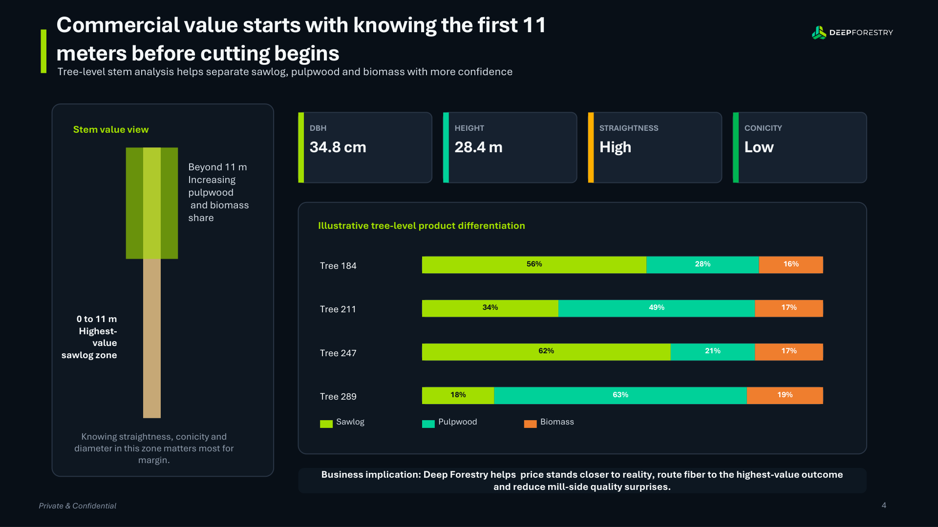
Validated mean absolute error (MAE) under 5% along the entire trunk profile.
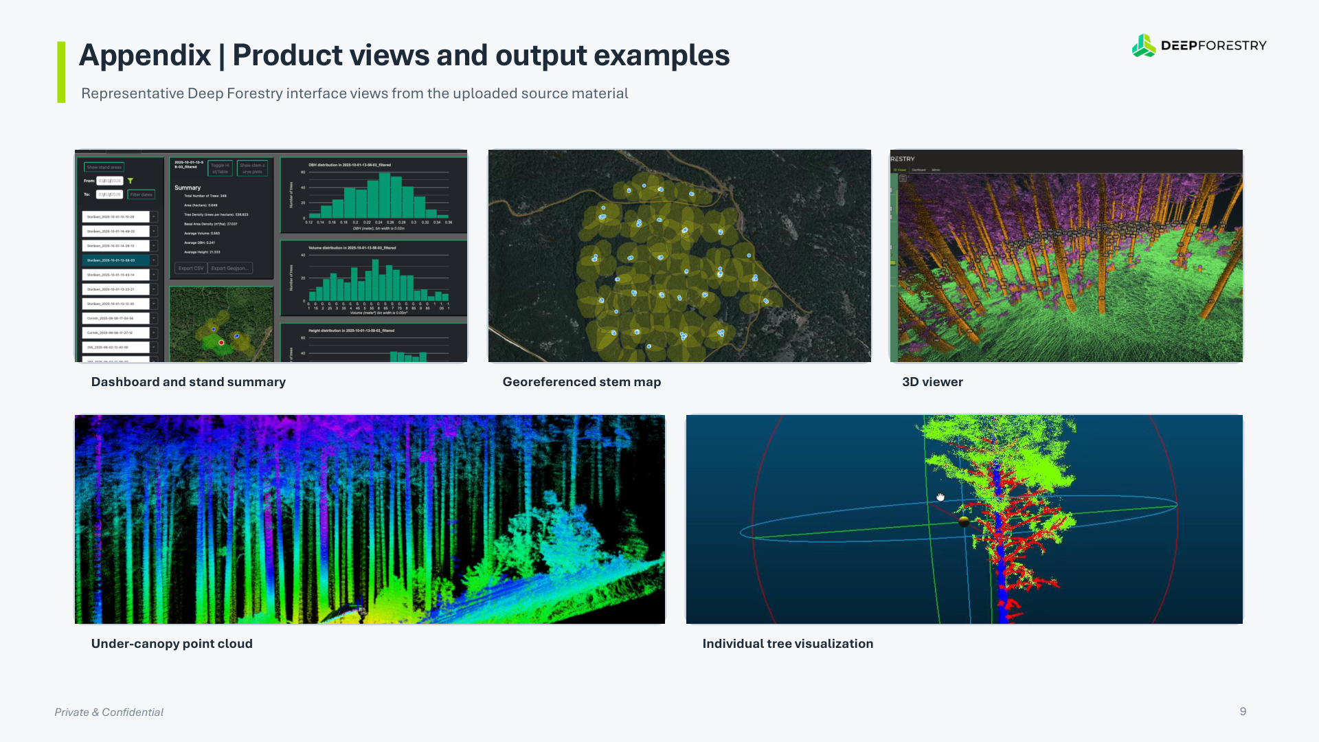
Autonomous indoor/outdoor reactive navigation mapping paths around tree stems.
The same below-canopy navigation flies within meters of steep outcrops, mapping geology with centimeter-scale detail.
Automated AI analysis in the cloud, connect the drone or payload online for mineral finding and deliverables.
Evaluating the first 11 meters of trunk diameter, straightness, and conicity determines the margin premium between high-value sawlogs and pulpwood. Illustrative portal metrics below (deck example: Tree 184).
Stem profile error: validated <5% along trunk length; ~1.6 cm mean absolute error overall in Radiata pine trials (see Validation).
Deployments by Deep Forestry globally; accuracy metrics from published pilots and government validation.
Japan’s forestry relied on slow manual labor; above-canopy drones lacked below-canopy precision. Deep Forestry mapped forests tree-by-tree with autonomous below-canopy flight, delivering inventory and ESG transparency. Verified against OWL laser and caliper baselines across multiple pilots.
“Deep Forestry’s AI and drone technology will transform forestry across Japan.” , Hiromasa Amano, President, Kajima Corporation
Government-funded industrial pilot validating Mean Absolute Error (MAE) via direct comparison against full-stem harvester metrics.
Forest surveys relied on manual caliper methods—slow, costly, and incomplete for inventory and logistics. Autonomous drone assessments delivered full-stem measurements with high precision and automated forest inventory.
“Deep Forestry’s AI-driven data analysis delivers speed and accuracy we couldn’t achieve with our other drones.” , Antonio de Marco Blanco, Innovation Manager, Cesefor
Serving Sweden’s largest forest companies (including SCA, Stora Enso, and Sveaskog), High Coast Forestry needed individual-tree data beyond manual and conventional drone surveys. Autonomous surveys and AI analytics delivered precise georeferenced tree data for major clients.
“A game-changer for forest planning. Deep Forestry gives us the accuracy we’ve always needed.” , Alexander Ramén, CEO, High Coast Forestry
Use-case verification
Low-cost operational fit checks executing simulated path runs against real local timber configurations.
Accuracy proofing
Active local pilot deployment in selected blocks, testing terrain limits and sensor coverage performance.
Downstream routing
A full quarterly deployment mapping plantation volumes directly to downstream supply planning metrics.
Deployment path
Digital simulation → onsite validation → operational pilot. Ready to explore your stand or concession?
Request a pilotTechnology partners
Survey-as-a-service or technology deployment in Malaysia and the region through ALJ Global—coordinated with Deep Forestry, Uppsala. Learn more at deepforestry.com
ALJ Global
Malaysia representative & regional deployment
Deep Forestry
Forest technology · Uppsala, Sweden
Tell us about your forestry or mineral use case. ALJ Global can arrange survey-as-a-service or a regional technology pilot with Deep Forestry systems. We will respond to schedule a digital simulation, field validation, or operational deployment.
Message received
ALJ GLOBAL SDN BHD · No.2309, Tingkat 1, Jalan Sj 10/1, Taman Seremban Jaya, 70450 Seremban, Negeri Sembilan.